GUI based Desktop Application for preparing Farmer’s Land Claim Documents as a part of Forest Right Act. 2006 Using Remote Sensing, GIS and GPS Technologies in MATLAB
-Feni Amrutiya & Jay Jivani
@ Dhirubhai Ambani Institute of Information and Communication Technology (DAIICT) , Gandhinagar.
"Tribal villagers across India were granted the right to own the land they had farmed when the Forest Rights Act was passed in 2006. Converting this right into legal title to required mapping, documentary proof, and several levels of approval. In India’s western state of Gujarat the NGO, Action Research in Community Health & Development (ARCH), and Liberty Institute have been collaborating to help tribal communities prepare and substantiate claims for their traditional land, using simple hand-held GPS instruments to survey their holdings, and map these onto satellite imagery. Developed a Desktop Application for automatic preparation of required documentary and substantiate claims of Satellite images. Application can Add, Modify, Print and Save all data for further requirement."
Introduction:
Millions of people in India live close to the land, but their homes, land or livelihood has no legal right. A few government officials have power over forests and forest dwellers. The result is both forests and people die. The Act recognizes the rights of forest dwellers and the defence is more responsible [B. Mitra, "Right to Land," [Online]. Available: http://righttoproperty.org/blog].
 |
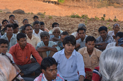
| PC: ARCH Vahini Team |
In India’s western state of Gujarat, the NGO, Action Research in Community Health & Development (ARCH), and Liberty Institute have been collaborating to help tribal communities prepare and substantiate claims for their traditional land, using simple hand-held GPS instruments to survey their holdings, and map these onto satellite imagery [A. Mehta, "Right to Property," Elegant Themes, [Online]. Available: http://righttoproperty.org/blog].
Problem:
We identified that they were facing problems in preparing claim files. They were using tool GPS Expert to generate claim for the individual farmers. They have to generate the individual claim file for every Farmer. In the Claim documents the farm of farmer should be highlighted. They gave printout of claim documentation form for individual farmer. Same process was repeated for all farmers. This was a very time-consuming and tedious process. We identify the problem and for overcome that problem we generate an application which automate the process of making claim files.
 |
| Image generated by Software (Land claim for FRA) |
Result:
Developed a Graphical User Interface (GUI) based desktop application in MATLAB 2014
- Support automation in print out
- Support automation in Land Claim Preparation
- Users can Store Land Claim Reports and Documents for further use (previously they cannot store)
- Prepare Database for Farmer’s Land Claim Documents
Conclusion:
Using ICT such as Remote Sensing, GIS, GPS & MATLAB technologies can made the preparation of Land claim documentation and reports easy, accurate and fast. It is very useful for farmers in Forest Right Act (FRA), 2006.
The satisfaction and euphoria that accompany the successful completion of any task would be incomplete without mentioning the name of person who made it possible, his constant guidance and encouragement crowns all efforts with our success.
We extend our gratitude to Dr. Ranendu Ghosh, Professor of Master of Science (Information and Communication Technology in Agriculture and Rural Development), Dhirubhai Ambani Institute of Information and Communication Technology, Gandhinagar, Gujarat for providing us with excellent infrastructure and awesome environment that laid potentially strong foundation.
We also thankful to Mr. Barun Mitra, Mr. Ambrish Mehta, Mr. Manohar for providing such good platform.
Wednesday, August 19, 2015
Share:


Thanks Buddy
ReplyDelete